Run-off or Drainage? How Nitrogen, Phosphorus, Sediment and E. coli Reach Water
Some of what leaves a farm runs over the ground; some soaks down through it. Which route a contaminant takes decides where to look for it, and which map helps.
The freshwater farm plan guidance lists two separate vulnerabilities for most kinds of land: nutrient loss through run-off and nutrient loss through drainage (MfE, Developing a freshwater farm plan, appendix 5). Its risk list goes further, splitting nitrogen, phosphorus and pathogens each into a surface-water and a groundwater risk, with sediment on its own. The split matters because the two routes need different maps and different fixes.
Two routes
- Run-off is water running over the surface: when rain comes faster than the soil can take it, or the soil is already full. It picks up soil, dung and whatever is on the ground, and carries them along swales and gullies to water.
- Drainage is water soaking down through the soil, to groundwater or into tile and open drains. It carries what dissolves, above all nitrate, and drains give it a shortcut to the stream.
| Contaminant | Main route | Where on a farm | Tools that help |
|---|---|---|---|
| Sediment | Run-off and erosion | Bare and pugged ground, tracks, steep faces, stream banks, slips | Flow Paths, Slope & Aspect, Elevation Change |
| Phosphorus | Run-off, mostly on soil particles | Swales and gullies below grazed or fertilised ground, gateways, tracks | Flow Paths, Ponding |
| E. coli and other bacteria | Run-off, and drains | Dung and effluent near water, stock crossings, swales, wet drained soils | Flow Paths, Downhill Path, Mapped water |
| Nitrogen (nitrate) | Drainage, through the soil | Urine patches, effluent areas, crops, free-draining soils, tile drains | Catchment, Wetness Map, Mapped water drains |
A rule of thumb, not a law: real farms mix both. Bacteria come out of drains as well as off the surface, and phosphorus can leach from some soils. Your adviser will know which matters most on yours.
See where the run-off goes on your farm
Select the titles and run Flow Paths. Tap any line for the land draining through it, then switch to Ponding. Free to use, no login.
Open Flow Paths →Map both routes in five steps
Shown on a dairy and drystock farm on the edge of the Piako flats in the Waikato, with the numbers the tools gave on 19 November 2026. The maps show the land; they say nothing about how this farm is run.
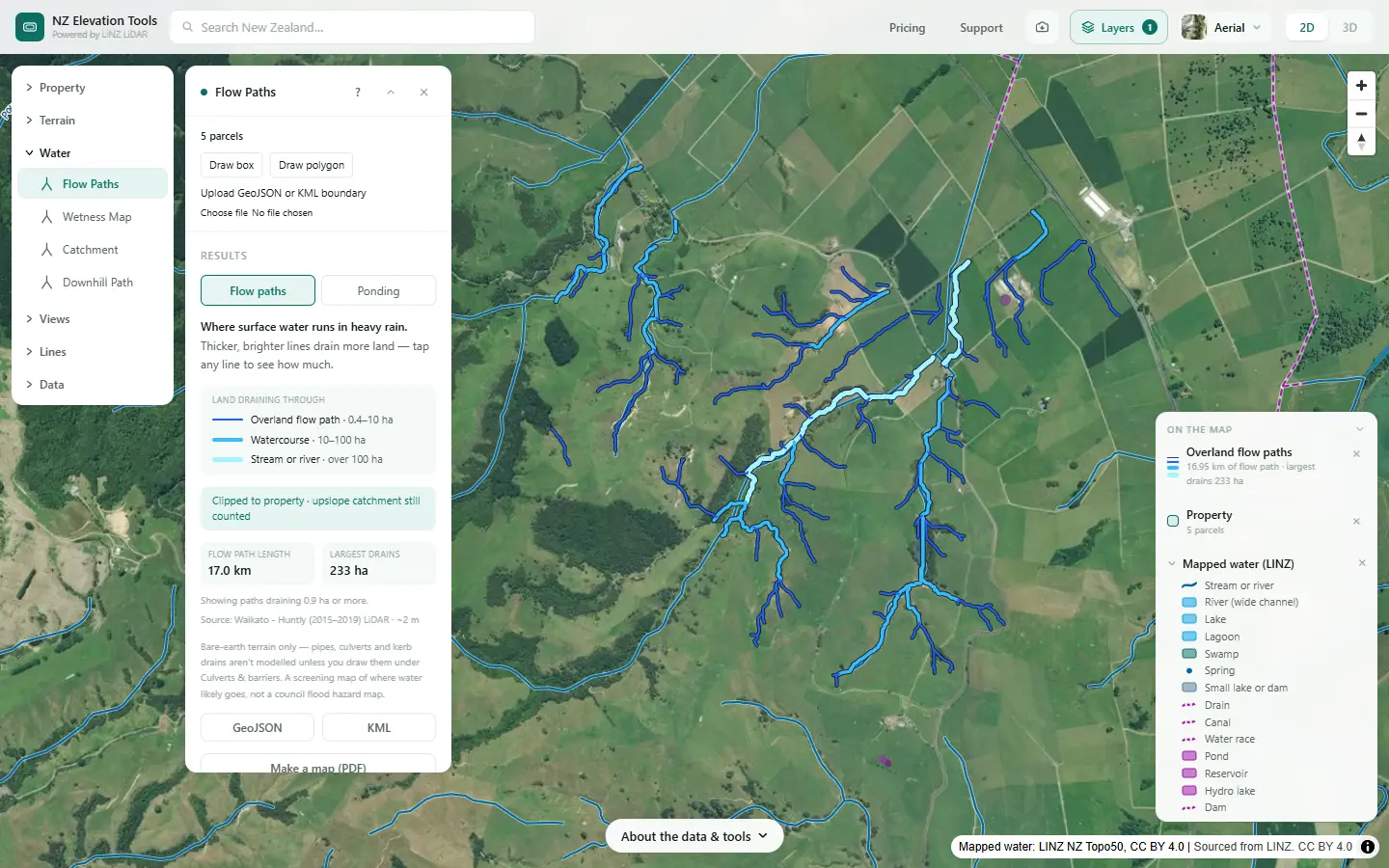
Map where the run-off goes
Select the farm and run Flow Paths. Each line is a route runoff takes over the ground, drawn bigger the more land drains through it. Sediment, phosphorus and bacteria move along these lines, so they are where to look first.
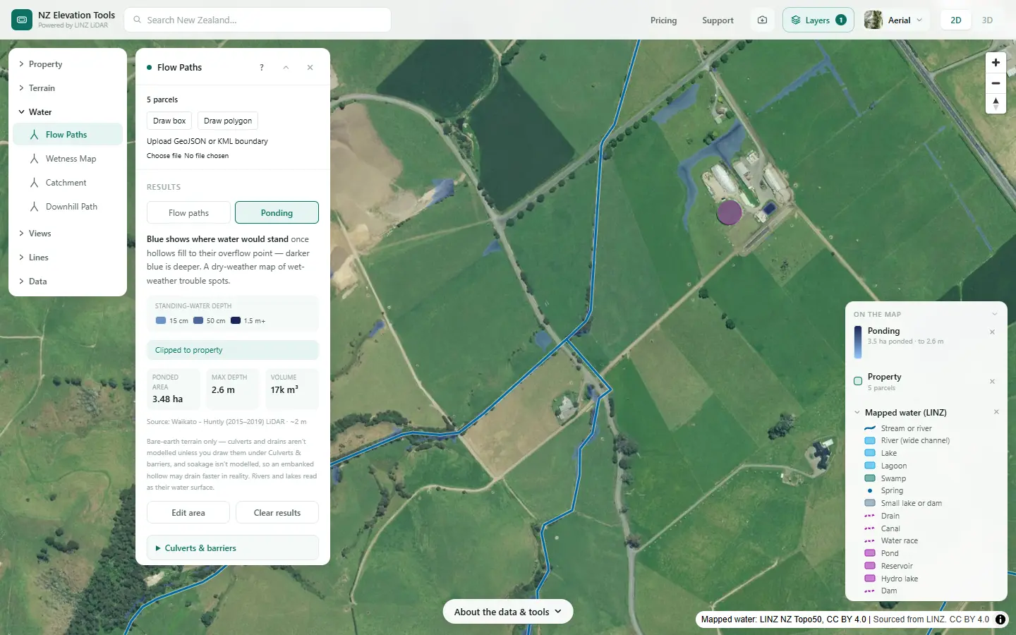
See where water sits
Switch Flow Paths to Ponding. Blue shows where water would stand once the hollows fill, with depth and volume. Ponded ground is where runoff slows and drops what it carries, where stock pug the soil, and where water soaks down to drains.
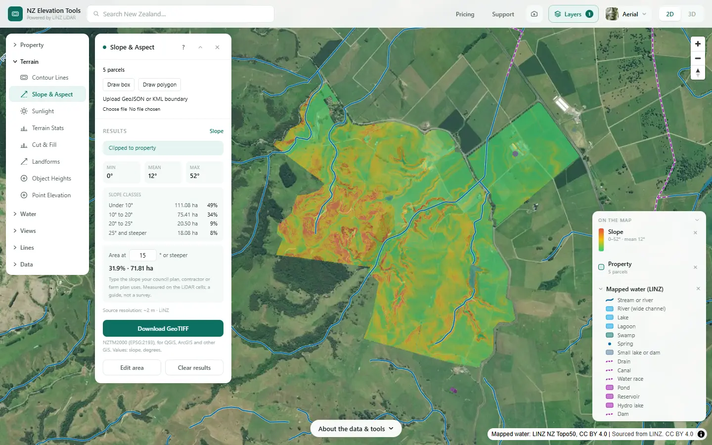
Find the steep ground that sheds water fast
Runoff starts sooner and moves faster on steep ground, and carries more soil. Slope & Aspect shows how much of the farm is in each slope class; the steep faces above a swale are where its sediment comes from.
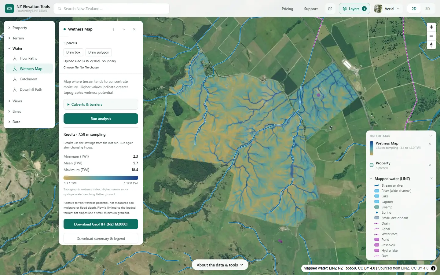
Find the wet ground where drainage matters
The Wetness Map shows where the shape of the land concentrates water. Those flats and hollows stay wet, were often drained, and are where water moves down through the soil to drains and groundwater, taking nitrate with it.
Follow a hot spot to water
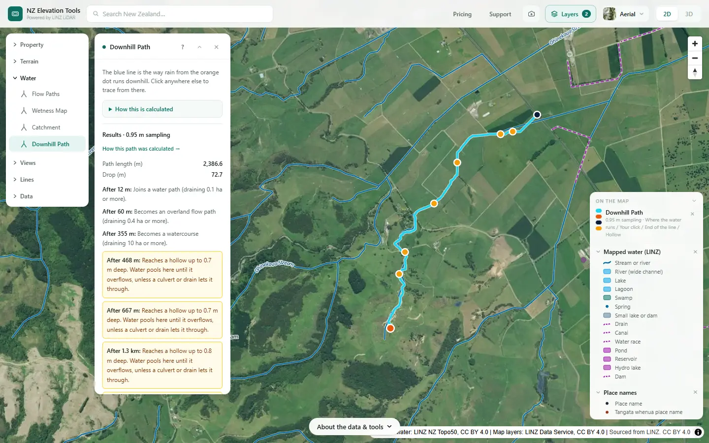
Click a gateway, a trough, a feed pad or a stock camp. Downhill Path shows where its runoff goes and how far it runs before it reaches a stream. A short path to water is a short path for sediment and bacteria.
Turn the maps into a plan
Saving the maps as images is free. With a pass, flow paths export as GeoJSON or KML and the slope and wetness grids as GeoTIFF.
What this cannot tell you
- How much is lost. Nothing here models sediment, nutrients or bacteria. It maps where water goes.
- What happens underground. Tile drains, groundwater and soil drainage class are not in the ground model. Use farm records, S-map and the council.
- How often a path runs. A flow path may run every winter week or once in a big storm.
- What the rules say. Regional councils set the rules on effluent, drains, critical source areas and setbacks. Check with them.
Related guides
- Where is the nitrate in my stream coming from?
- Critical source areas: map them on your farm
- Mapping farm drainage
- How to divide your farm into land units
Screenshots from NZ Elevation Tools of a dairy and drystock farm on the edge of the Piako flats in the Waikato, with legal descriptions and owners blurred. Aerial photos and LiDAR from LINZ. Sourced from the LINZ Data Service and licensed by Regional Software Holdings Limited and Waikato Regional Council for re-use under the Creative Commons Attribution 4.0 International licence.
Frequently asked questions
What is the difference between run-off and drainage?
Run-off is water that runs over the ground surface when rain falls faster than the soil can take it, or the soil is already full. Drainage is water that soaks in and moves down through the soil, to groundwater or to a tile or open drain. The same paddock can do both, in different weather.
Which contaminants travel in run-off?
Sediment, phosphorus (which sticks to soil particles), and E. coli and other bacteria from dung and effluent. They need water moving over the surface to carry them, so they gather where runoff gathers: swales, gullies, tracks, gateways and hollows.
Which contaminants travel in drainage?
Mainly nitrate, because it dissolves and moves with the water through the soil. Drains also carry bacteria and some phosphorus, especially from wet, drained soils and where effluent is applied to wet ground, because drains are a shortcut from the soil surface to the stream.
Can I map drainage the way I can map run-off?
Only part of it. LiDAR shows the surface, so it maps runoff routes and ponding well. It shows where the land concentrates water, which is where soils are often wet and drains were laid, but it cannot see tile drains or groundwater. Those come from farm records, the soil map and the council.
What do critical source areas have to do with this?
They are the run-off side. A critical source area is a swale, gully or hollow where runoff gathers and can carry contaminants to water. Mapping where runoff gathers is how you find the likely ones.